Tsum Valley Larke La Pass Trek
Trip Overview
The Tsum Valley Larke La Pass Trek – 21 Days is a remarkable Himalayan journey that combines the peaceful and culturally rich Tsum Valley with the dramatic landscapes of the Manaslu region and the challenging crossing of Larke La Pass at 5,106 metres. Designed for trekkers who wish to experience both cultural depth and high-altitude adventure, this route offers a rewarding combination of remote villages, traditional monasteries, mountain scenery, forest trails, glacial valleys and one of the most memorable high passes in Nepal.
The journey begins in Kathmandu with an overland drive through the hills and river valleys of central Nepal to Machhakhola. From here, the trek gradually follows the Budhi Gandaki valley through settlements such as Jagat before turning towards the secluded Tsum Valley. The landscape becomes increasingly peaceful as the trail passes Lokpa, Chumling, Chhokangparo and Nile, where traditional stone houses, cultivated terraces, prayer walls and Buddhist monuments reflect the distinctive character of this remote Himalayan valley.
One of the important cultural experiences of the trek is the visit to Mu Gompa at approximately 3,700 metres. Surrounded by a broad mountain landscape near the upper end of Tsum Valley, Mu Gompa provides an opportunity to experience the spiritual atmosphere and long-established Buddhist traditions of the region. The acclimatization day around the Nile and Mu Gompa also allows the body additional time to adjust before continuing towards higher elevations later in the journey.
After exploring Tsum Valley, the route returns through Chumling and joins the main Manaslu trail towards Deng and Namrung. From Namrung, the character of the landscape changes considerably. Dense forests gradually open into broad alpine valleys while impressive views of the surrounding Himalayan peaks become more prominent. The trek then continues to Shyala, one of the scenic settlements of the upper Manaslu region.
From Shyala, the journey includes an excursion towards Pungyen Gompa at around 4,040 metres before continuing to Samagaun. The area around Pungyen offers an impressive perspective of the surrounding mountains and glaciers, while Samagaun serves as an important acclimatization and exploration base beneath Mount Manaslu.
An additional exploration day at Samagaun is planned for the hike towards Manaslu Base Camp at approximately 4,400 metres. This demanding but rewarding side trip takes trekkers into a dramatic high-altitude landscape of glaciers, rugged slopes and towering Himalayan peaks. After returning to Samagaun, the journey continues gradually towards Samdo at 3,875 metres.
Another acclimatization day is included at Samdo, with the possibility of exploring Samdo Ri and the surrounding highland area. These planned acclimatization days are an important part of the itinerary, allowing trekkers to gain elevation gradually before approaching the highest and most demanding stage of the journey.
From Samdo, the trail climbs to Dharmashala at approximately 4,460 metres, the final overnight stop before crossing Larke La Pass. The following day is the major challenge and one of the greatest highlights of the trek. Starting early, the route climbs through a remote high-altitude landscape towards Larke La Pass at 5,106 metres. From the pass, trekkers can enjoy an extraordinary Himalayan panorama before beginning the long descent towards Bhimtang at 3,590 metres.
The scenery changes again after reaching Bhimtang. The trail descends through alpine meadows, forests and river valleys towards Gowa or Tilche, gradually returning to warmer and greener surroundings. The trekking section concludes with a drive to Besisahar, followed by the journey back to Kathmandu.
Overall, the Tsum Valley Larke La Pass Trek is well suited to experienced and physically prepared trekkers seeking more than a conventional mountain trek. Its greatest strength is its diversity: secluded Buddhist communities in Tsum Valley, the impressive upper Manaslu landscape, visits to historic monasteries, carefully planned acclimatization days, the opportunity to explore Manaslu Base Camp and the adventurous crossing of the 5,106-metre Larke La Pass.
Rather than focusing only on reaching a high mountain pass, this journey allows trekkers to experience how landscapes, cultures and communities gradually change from the lower Budhi Gandaki valley to the remote Tibetan-influenced settlements of Tsum and finally to the alpine wilderness surrounding Manaslu. It is a demanding journey, but one that offers an unusually complete experience of culture, nature and high-altitude trekking in Nepal.
Trip Highlights
Himalayan Sherpa Exodus Team honestly requests for everyone!
Explore quietly. Travel respectfully. Experience the Himalaya beyond the ordinary.
Trip Highlights
- Explore the Remote Tsum Valley : Walk into one of Nepal's peaceful Himalayan valleys, passing traditional villages, terraced farmland, stone houses, Buddhist monuments and settlements that have preserved a strong connection with Tibetan-influenced Himalayan culture.
- Visit Mu Gompa at 3,700 Metres : Spend an acclimatization day exploring Mu Gompa, one of the important monasteries of upper Tsum Valley, while enjoying the quiet atmosphere and impressive mountain surroundings.
- Experience Traditional Himalayan Buddhist Culture : Encounter mani walls, prayer flags, chortens, monasteries and centuries-old religious traditions throughout the Tsum and Manaslu regions.
- Trek Through Changing Himalayan Landscapes : Experience remarkable geographical variety as the trail moves from subtropical river valleys and forests to open alpine terrain, glacial landscapes and high mountain passes.
- Scenic Journey Through the Budhi Gandaki Valley : Follow sections of the Budhi Gandaki River through deep valleys, suspension bridges, forests, cultivated terraces and traditional settlements on the approach to Tsum Valley and Manaslu.
- Stay in Beautiful Upper-Manaslu Villages : Pass through Namrung, Shyala, Samagaun and Samdo, where traditional mountain settlements sit beneath some of the most dramatic Himalayan scenery along the route.
- Visit Pungyen Gompa at Around 4,040 Metres : Take a rewarding side excursion from Shyala towards Pungyen Gompa, surrounded by an impressive natural amphitheatre of mountains and glacial landscapes.
- Explore Manaslu Base Camp at Approximately 4,400 Metres : Enjoy a challenging acclimatization hike from Samagaun towards Manaslu Base Camp and experience the powerful mountain environment beneath Mount Manaslu.
- Acclimatization and Exploration at Samdo : Spend an additional day at Samdo with the opportunity to explore Samdo Ri and surrounding highland areas while preparing for the Larke La crossing.
- Cross Larke La Pass at 5,106 Metres : Complete the most demanding and rewarding stage of the trek by crossing Larke La, the highest point of the journey, surrounded by a spectacular high-altitude Himalayan landscape.
- Dramatic Descent to Bhimtang : Descend from the pass into the broad and beautiful valley of Bhimtang, where mountain views, alpine terrain and open landscapes create a memorable conclusion to the high-altitude section.
- A Trek Combining Two Distinct Himalayan Regions : Experience both the cultural isolation of Tsum Valley and the dramatic mountain scenery of the Manaslu Circuit within one carefully connected trekking itinerary.
- Gradual Acclimatization for High-Altitude Trekking : Dedicated acclimatization and exploration days at Nile, Samagaun and Samdo provide valuable time for the body to adjust before reaching the highest elevations of the route.
- A Challenging Journey for Adventure-Minded Trekkers : With long walking days, remote trails, elevations above 5,000 metres and a major Himalayan pass crossing, the trek offers a genuine sense of achievement for well-prepared trekkers.
- A Complete 21-Day Himalayan Experience : From arrival in Kathmandu to remote valleys, Buddhist monasteries, high mountain settlements, Manaslu Base Camp and Larke La Pass, the itinerary brings together cultural exploration and serious Himalayan trekking in one comprehensive journey.
Day 01 :
Arrival in Kathmandu, Nepal
Welcome to Nepal and the beginning of your Tsum Valley and Larke La Pass adventure. Upon arrival at Tribhuvan International Airport in Kathmandu, a representative from Himalayan Sherpa Exodus Team Treks & Expedition (P) Ltd. will welcome you and assist with your transfer to the hotel.
Kathmandu lies in a broad valley surrounded by the middle hills of central Nepal at approximately 1,350 metres above sea level. Although the great Himalayan chain lies farther north, on a clear day the higher viewpoints around the Kathmandu Valley can offer distant glimpses of snow-covered ranges.
After reaching the hotel, you can rest following your international journey and become familiar with the surroundings. Depending on your arrival time, there may also be an opportunity to walk around the lively streets of Kathmandu.
Before beginning the trek, our team will provide the necessary trip briefing and review the route, trekking equipment, weather considerations, high-altitude precautions and other practical information for the journey ahead.
Overnight: Kathmandu
Altitude: Approx. 1,350 m
Day 02 :
Drive from Kathmandu to Machha Khola
Altitude: 905 m
Driving Distance: Approx. 160 km
Driving Time: Approx. 9–10 hours
After breakfast, we leave Kathmandu and begin a long but highly varied overland journey towards Machha Khola, the starting point of our walking adventure.
The road initially crosses the densely settled hills surrounding Kathmandu before heading west and northwest through Nepal's middle-hill landscape. Depending on current road conditions, the commonly used route passes through the Dhading area before continuing towards Arughat, Soti Khola and finally Machha Khola.
During the first section of the journey, the scenery is characterised by green hills, river valleys, terraced farmland and scattered settlements. Rice terraces, maize fields and traditional hillside villages illustrate how closely rural communities in the middle hills are connected with the landscape.
As we travel farther towards Gorkha, the terrain becomes progressively more rugged. The broad agricultural valleys gradually narrow, and the road begins to follow the drainage system connected with the Budhi Gandaki River, one of the defining geographical features of the Manaslu region.
Beyond Arughat and Soti Khola, the landscape becomes increasingly dramatic. The road winds above rivers and streams, with steep forested slopes rising from the valley floor. Depending on recent road improvements and seasonal conditions, some sections may be rough, dusty or muddy.
Unlike later trekking days, the major high Himalayan peaks are not continuously visible from this lower valley because surrounding hills often block the northern skyline. However, the journey clearly demonstrates the geographical transition from the Kathmandu Valley and middle hills towards the deep river gorges of northern Gorkha.
Machha Khola is situated beside the Budhi Gandaki river system in a narrow valley surrounded by steep green hills. Arriving here gives the first real sense of entering the remote Manaslu landscape.
Overnight: Machha Khola
Day 03 :
Trek from Machha Khola to Jagat
Starting Altitude: 905 m
Ending Altitude: 1,340 m
Walking Distance: Approx. 16 km
Walking Time: Approx. 6–7 hours
Today our trek begins properly as we leave Machha Khola and follow the dramatic valley of the Budhi Gandaki River upstream.
The trail travels through a landscape shaped by the river over thousands of years. Steep cliffs, narrow gorges, forested slopes and rocky riverbanks are characteristic of this section. Rather than gaining altitude continuously, the trail repeatedly climbs and descends as it negotiates the irregular sides of the gorge.
We pass small settlements and cultivated areas tucked into whatever relatively level ground is available between the river and surrounding hills. The subtropical vegetation of the lower valley remains noticeable, with broadleaf forests, bamboo, shrubs and agricultural terraces creating a green environment.
As we continue north, suspension bridges become an important feature of the route. The Budhi Gandaki cuts deeply between the hills, requiring the trail to cross from one bank to another where cliffs or side valleys make progress difficult.
The route also passes through the general area of Khorlabesi and Tatopani, where the valley remains narrow and humid. From here the trail continues over ridges and across tributary streams before steadily gaining elevation.
At this stage, the high mountains are still partly hidden behind the steep valley walls. The scenery is therefore dominated less by open Himalayan panoramas and more by the impressive scale of the Budhi Gandaki gorge itself.
Eventually we reach Jagat, a traditional stone-built settlement situated on a comparatively open section of the valley. Its stone-paved pathways and closely arranged houses give the village a distinctive mountain character.
Jagat is also an important geographical and cultural transition point. From here onward, the landscape gradually begins to reflect the stronger Himalayan and Tibetan Buddhist influences found deeper within the Manaslu Conservation Area.
Overnight: Jagat
Day 04 :
Trek from Jagat to Lokpa
Starting Altitude: 1,340 m
Ending Altitude: 2,240 m
Walking Distance: Approx. 13 km
Walking Time: Approx. 6–7 hours
Leaving Jagat, we continue northward through the Budhi Gandaki valley before eventually turning away from the main Manaslu route towards Tsum Valley.
The trail initially climbs above the river through a combination of terraced farmland, forest and exposed hillside. As elevation increases, the valley begins to open enough to provide occasional views towards the higher Himalayan ridges.
We pass settlements such as Salleri and continue towards the broader agricultural area around Sirdibas and Philim. The changing architecture, prayer structures and Buddhist symbols along the route gradually reveal our movement into a culturally different part of northern Gorkha.
In favourable weather, this section can provide early views towards Sringi Himal, also written as Shringi Himal, which rises prominently north of the lower Budhi Gandaki valley. Its snow-covered slopes provide one of the first clear indications that we are approaching the high Himalayan zone.
Beyond Philim, the trail climbs through increasingly quiet forest and passes the Ekle Bhatti area. Farther ahead lies an important trail junction. The main Manaslu Circuit continues along the Budhi Gandaki towards Deng and the upper Manaslu valley, while our route turns towards the secluded Tsum Valley.
This junction represents more than simply a change of trail. Geographically, we are leaving the main Budhi Gandaki corridor and entering the drainage system of the Shiar Khola, also written Siyar Khola, which flows down from the high Tsum Valley before joining the larger river system.
The trail towards Lokpa climbs through pine and rhododendron forest on slopes high above the gorge. Waterfalls descend from the surrounding cliffs, and the terrain feels considerably more enclosed and remote.
When clouds remain clear, sections around Lokpa can reveal views towards Himalchuli, Baudha Himal and mountains of the Ganesh Himal region. These peaks form part of the impressive mountain walls surrounding the wider Tsum-Manaslu landscape.
We eventually reach Lokpa, positioned near the entrance to Tsum Valley. Surrounded by forested ridges and deep river gorges, Lokpa feels distinctly more isolated than the villages of the lower Budhi Gandaki.
Overnight: Lokpa
Day 05 :
Trek from Lokpa to Chumling
Starting Altitude: 2,240 m
Ending Altitude: 2,470 m
Walking Distance: Approx. 7.8 km
Walking Time: Approx. 4–5 hours
Although today's distance is relatively short, the trail between Lokpa and Chumling contains considerable geographical variation, with repeated climbs and descents through steep forested terrain.
Leaving Lokpa, we enter a quieter section of the Tsum Valley approach. The trail passes through dense woodland dominated by pine, rhododendron and other Himalayan vegetation. In spring, flowering rhododendrons can add considerable colour to the forested slopes.
The route descends towards tributary streams before climbing again along the side of the gorge. In several places, the steepness of the terrain becomes obvious as the trail has been constructed against cliffs or above the river.
Waterfalls drop from the surrounding slopes, particularly where side streams descend sharply towards the Shiar Khola.
As we progress farther into the valley, glimpses of the higher mountains begin to appear through openings in the forest. Depending on cloud conditions, trekkers may see parts of Sringi Himal, Baudha Himal and the Ganesh Himal massif.
Eventually the route crosses the Shiar Khola and climbs towards Chumling. The valley begins to feel broader here, and the contrast between cultivated land and the steep forested mountainsides becomes increasingly attractive.
Chumling marks our arrival in the Lower Tsum Valley. Traditional stone houses, agricultural fields, mani walls, chortens and Buddhist religious structures reflect the distinctive cultural identity of the region.
From suitable viewpoints around Chumling, the surrounding Himalayan ridges become more prominent. In clear weather, the Ganesh Himal region and Sringi Himal contribute an impressive snow-covered backdrop above the valley.
The combination of river geography, traditional settlement patterns and Buddhist landscape makes Chumling an important introduction to the deeper Tsum Valley experience.
Overnight: Chumling
Day 06 :
Trek from Chumling to Chhokangparo
Starting Altitude: 2,470 m
Ending Altitude: 3,031 m
Walking Distance: Approx. 8 km
Walking Time: Approx. 4–5 hours
Today's trek brings one of the most noticeable geographical transitions of the journey as we leave the relatively enclosed Lower Tsum Valley and climb towards the wider landscapes of Upper Tsum.
After leaving Chumling, the trail crosses the river system and continues through a mixture of forest, cultivated slopes and traditional settlements. The route gains more than 500 metres in elevation, so the surrounding vegetation gradually changes as we climb.
We pass through areas near Rainjam and cross side streams flowing down from the mountains. The trail then approaches the settlement of Gho before beginning the stronger climb towards Chhokangparo.
As elevation increases, the deep forest begins to break into more open terrain. The valley broadens noticeably, allowing much wider views of the surrounding mountains than on previous days.
This section is particularly rewarding in clear weather. Ganesh Himal becomes one of the dominant mountain features, while Himalchuli may also appear to the west or southwest depending on the exact position along the trail and local cloud cover. Parts of Baudha Himal and the surrounding high ridges can also contribute to the panorama.
Rather than appearing only as distant white points, the mountains now begin to feel closely connected with the valley itself. Their glaciers and snowfields feed the streams that eventually become part of the Shiar Khola and Budhi Gandaki river systems.
The approach to Chhokangparo, also commonly written Chhekampar or Chhokang Paro, provides an increasingly strong sense of entering a high Himalayan valley.
Chhokangparo lies on an open plateau-like section of the Upper Tsum Valley. Compared with the narrow gorge below Lokpa, the geographical character here is remarkably different. Broad cultivated fields spread around clusters of traditional stone houses, while the higher slopes rise towards the Himalayan borderlands.
On a clear afternoon, the snow-covered Ganesh Himal massif forms one of the outstanding features of the landscape.
Overnight: Chhokangparo
Day 07 :
Trek from Chhokangparo to Nile
Starting Altitude: 3,031 m
Ending Altitude: 3,360 m
Walking Distance: Approx. 10 km
Walking Time: Approx. 6–7 hours
Today we continue deeper into Upper Tsum Valley, travelling through one of the most culturally and geographically distinctive sections of the trek.
Unlike the steep forested route below Chumling, much of the upper valley consists of comparatively open terrain. The trail follows the broad valley shaped by the Shiar Khola, surrounded by dry mountain slopes, cultivated fields and enormous Himalayan ridges.
Leaving Chhokangparo, we pass a series of small settlements and agricultural areas. Barley, buckwheat and potatoes are among the crops traditionally suited to these higher elevations, where the growing season is considerably shorter than in the lower valleys.
The trail passes through or close to settlements such as Lamagaon, Lar, Phurbe, Pangdun and Chhule, depending on the exact trail used.
Throughout this section, Buddhist culture becomes increasingly visible in the landscape. Long mani walls, chortens, prayer flags and religious structures are encountered beside the trail. These features are not isolated monuments but part of the everyday geography of Upper Tsum.
The Ganesh Himal massif dominates many views to the south and southeast. Under favourable weather conditions, its enormous snow and ice-covered faces appear above the darker slopes surrounding the valley.
To the wider north and west, additional high ridges of the Tsum-Manaslu border region shape the horizon. Because mountain visibility depends heavily on clouds, season and the exact position of the trekker within the valley, individual peaks may appear and disappear throughout the day.
The atmosphere becomes increasingly high-altitude as we approach Chhule and Nile. Trees become much less dominant than in the lower valley, and open fields, rocky slopes and alpine vegetation increasingly define the landscape.
Nile, at approximately 3,360 metres, is among the highest permanent settlements in the upper valley and forms an excellent base for the following day's excursion towards Mu Gompa.
Overnight: Nile
Day 08 :
Acclimatization Day – Excursion to Mu Gompa
Nile: 3,360 m
Mu Gompa: Approx. 3,700 m
Walking Distance: Approx. 4.3 km
Walking Time: Approx. 3–4 hours
Today is deliberately kept as an acclimatization and exploration day. Rather than making a large change in sleeping altitude, we hike higher towards Mu Gompa before returning, allowing our bodies additional time to adjust to the thinner mountain air.
Leaving the Nile, the route continues north through the uppermost section of Tsum Valley. The landscape here has a distinctly high-Himalayan character. Agricultural land becomes more limited, settlement becomes increasingly sparse and the valley is surrounded by bare ridges and snow-covered mountains.
The Shiar Khola and its upper tributaries originate from the glaciers, snowfields and high mountain catchments surrounding this part of the valley. Walking through this landscape provides a clear view of how Himalayan snow and ice gradually feed the rivers that descend towards the lower Budhi Gandaki.
As we climb towards Mu Gompa, the views become progressively wider. On clear days, the Ganesh Himal massif is particularly impressive. Ganesh Himal I, traditionally known as Yangra, forms part of the massive Himalayan barrier dominating this region.
The high ridges around Upper Tsum also create a striking sense of proximity to the Tibetan Plateau. The international border lies farther north beyond the mountains and high passes, and the relatively dry landscape reflects Tsum Valley's position close to the trans-Himalayan climatic zone.
Mu Gompa, standing at approximately 3,700 metres according to our itinerary, is one of the most important religious landmarks of the upper valley. Its location beneath high mountains gives it an atmosphere quite different from monasteries in the lower, greener regions of Nepal.
Here we have time to appreciate the monastery surroundings, Buddhist heritage and immense scale of the Himalayan landscape.
The purpose of today's walk is not simply sightseeing. Hiking to a higher elevation and returning to sleep lower at Nile contributes to gradual acclimatization, which becomes increasingly important as our itinerary later progresses towards Samagaun, Samdo, Dharmashala and eventually the 5,106-metre Larke La Pass.
After completing our visit, we descend along the familiar upper-valley trail to Nile.
Overnight: Nile
Day 09 :
Trek from Nile to Chumling
Starting Altitude: 3,360 m
Ending Altitude: 2,470 m
Walking Distance: Approx. 17 km
Walking Time: Approx. 7–8 hours
Today is a longer trekking day as we leave the high settlements of Upper Tsum and descend almost 900 metres back towards Chumling.
Although we are retracing part of our earlier route, walking in the opposite direction provides a completely different perspective of the valley. Himalayan peaks that were previously behind us now appear directly ahead or to the side, while the full shape of the valley becomes easier to appreciate from elevated sections of the trail.
Leaving Nile, we descend through Chhule and continue across the broad upper valley. Traditional fields, mani walls, chortens and stone villages again accompany the route.
In clear morning conditions, the Ganesh Himal massif can provide particularly impressive views. Early hours often offer the best opportunity for mountain visibility before afternoon clouds develop, although conditions naturally vary with season and weather.
We continue through the wider landscapes around the Chhokangparo area before dropping more noticeably towards Lower Tsum.
The geographical contrast becomes increasingly obvious during the descent. Open alpine and high-mountain terrain gradually gives way to larger areas of forest, deeper river gorges and more humid vegetation.
Views towards Himalchuli, Baudha Himal, Sringi Himal and the Ganesh Himal region may appear at different sections of the route, although surrounding ridges can temporarily conceal individual mountains.
Eventually we descend towards the Shiar Khola and return to Chumling.
After several days in the open Upper Tsum landscape, the forested setting around Chumling feels noticeably greener and warmer.
Overnight: Chumling
Day 10 :
Trek from Chumling to Deng
Starting Altitude: 2,470 m
Ending Altitude: 1,860 m
Walking Distance: Approx. 15 km
Walking Time: Approx. 6–7 hours
Today marks an important turning point in our complete Tsum Valley and Larke La journey. We leave Tsum Valley and reconnect with the main Manaslu Circuit, beginning the next stage of our approach towards the high mountains surrounding Manaslu.
From Chumling, the trail initially descends through the forested Shiar Khola valley. We cross streams and negotiate the familiar steep terrain above the gorge, gradually returning towards Lokpa.
The lush forest contains pine, rhododendron and mixed Himalayan vegetation, creating a striking contrast with the open terrain experienced around Nile and Mu Gompa.
After passing the Lokpa area, we continue towards the junction where the Tsum Valley route meets the main Manaslu trail.
Geographically, this is a significant point. Until now, our journey has followed the Shiar Khola tributary system into Tsum Valley. From here, we return to the much larger Budhi Gandaki valley, which we will follow progressively north and west towards Deng, Namrung, Lho, Shyala, Samagaun and eventually the high country beneath Mount Manaslu.
Instead of returning south towards Jagat, we now turn upstream along the main Manaslu route.
The valley is once again narrow and dramatic. Towering forested cliffs rise above the Budhi Gandaki, while waterfalls descend from side valleys. Suspension bridges and steep hillside trails remain characteristic features.
Although the enormous summit of Mount Manaslu, 8,163 metres, does not yet dominate the view from every section because of the deeply enclosed valley, today's route is geographically bringing us closer to the Manaslu massif.
Depending on weather and the openings between ridges, trekkers may still obtain views towards Sringi Himal and surrounding snow peaks, while the character of the mountain skyline gradually shifts away from Ganesh Himal and towards the central Manaslu range.
The day's walk eventually brings us to Deng at approximately 1,860 metres, a small settlement situated within the Budhi Gandaki valley.
Reaching Deng completes the Tsum Valley section of our journey and begins another fascinating geographical chapter. From tomorrow onward, the trail steadily gains altitude through Namrung and Shyala, where some of the journey's most impressive close-range views of Manaslu, Himalchuli, Ngadi Chuli and surrounding peaks begin to emerge.
Overnight: Deng
Day 11 :
Trek from Deng to Namrung
Starting Altitude: 1,860 m
Ending Altitude: 2,630 m
Walking Distance: Approx. 19.5 km
Walking Time: Approx. 7–8 hours
After breakfast in Deng, we continue northward through the upper Budhi Gandaki Valley, gradually entering a higher and more distinctly Himalayan environment. Today is a fairly long walking day, with a significant gain in altitude as the trail leads from the warmer forested valley around Deng towards Namrung.
Soon after leaving Deng, the route crosses the Budhi Gandaki River and climbs through steep terrain towards small settlements scattered above the river. The valley remains narrow in places, with the river flowing far below between forested cliffs.
The trail passes through areas around Rana and Bihi Phedi before continuing farther upstream. Mani walls, prayer stones and small Buddhist structures become increasingly common, indicating the stronger Tibetan cultural influence of the upper Manaslu region.
Much of today's journey passes through beautiful forest. Pine, fir, rhododendron and mixed Himalayan woodland replace much of the lower-elevation vegetation seen earlier in the trek. Numerous side streams descend from the surrounding mountains and eventually join the Budhi Gandaki.
Depending on the trail chosen, the route may pass through or near Prok and Ghap. Prok lies above the main river corridor and is surrounded by agricultural fields and forested slopes, while Ghap sits closer to the Budhi Gandaki.
As we move deeper into the valley, the surrounding mountain walls become considerably higher. In clear weather, Sringi Himal can still be seen in parts of this region, while the first stronger views towards Himalchuli and other peaks of the Manaslu massif begin to emerge.
The final section involves further climbing through forest before reaching Namrung at approximately 2,630 metres.
Namrung marks another important geographical transition. The deep lower gorge is gradually giving way to a broader high-mountain valley, and from this point onward the snow peaks become an increasingly dominant part of the journey. Clear conditions around Namrung can reveal views towards Himalchuli and parts of the Ganesh Himal region.
Overnight: Namrung
Day 12 :
Trek from Namrung to Shyala
Starting Altitude: 2,630 m
Ending Altitude: 3,500 m
Walking Distance: Approx. 16 km
Walking Time: Approx. 5–6 hours
Today's trek is one of the major scenic transitions of the entire journey. As we leave Namrung, the valley opens progressively and the great mountains of the Manaslu massif begin to appear at much closer range.
The trail initially climbs through forest and cultivated land towards Lihi, a traditional stone-built village surrounded by barley fields, terraces and mountains.
From Lihi, the route continues across several small streams draining the high slopes surrounding the valley. The vegetation becomes thinner as elevation increases, although sections of pine and fir forest continue between settlements.
We continue towards Sho village, where the mountain scenery begins to change dramatically. When the weather is clear, Manaslu, rising to 8,163 metres, starts to become one of the defining features of the northern skyline.
Mount Manaslu is the eighth-highest mountain in the world and forms the central geographical landmark of this entire section of the trek. The Nepal Tourism Board describes the Manaslu region as extending from subtropical Himalayan foothills to arid trans-Himalayan high pastures near Tibet, a transition that becomes increasingly obvious from this stage onward.
The route continues towards Lho, another important village of the upper Budhi Gandaki valley. From the open areas surrounding Lho, Manaslu can appear remarkably close, its huge snow-covered slopes rising above the valley.
Traditional chortens, mani walls and monasteries blend naturally into the landscape. Here the cultural and physical geography become closely connected: villages occupy relatively level terraces while glaciers and snowfields rise thousands of metres above them.
Beyond Lho, we continue climbing towards Shyala. Trees gradually become more scattered and the valley opens into a magnificent natural amphitheatre.
Shyala at approximately 3,500 metres is one of the most impressive mountain-viewing locations of the trek. In favourable weather, the surrounding skyline includes Mount Manaslu, Himalchuli and Ngadi Chuli, together with several subsidiary ridges and snow peaks of the Manaslu massif.
The geographical scale is particularly striking here. High peaks rise on several sides of the village while glacial valleys descend between them, giving Shyala a distinctly enclosed Himalayan setting.
Sunrise and late-afternoon light can be especially beautiful when clear weather illuminates the snow-covered faces surrounding the valley.
Overnight: Shyala
Day 13 :
Shyala to Pungyen Gompa and Continue to Samagaun
Starting Altitude: 3,500 m
Highest Point: Pungyen Gompa – approx. 4,040 m
Ending Altitude: Samagaun – 3,520 m
Walking Distance: Approx. 15.6 km
Walking Time: Approx. 5–6 hours
Today combines high-altitude scenery, Buddhist culture and one of the finest close-range mountain environments of the Manaslu region.
Leaving Shyala, we head towards the broad glacial valley leading to Pungyen Gompa, climbing gradually away from the main trail.
The landscape becomes increasingly open as we leave the village behind. Alpine grassland and grazing areas replace much of the forest, while enormous mountain walls rise around the valley.
As we gain altitude, views towards Manaslu, Himalchuli and Ngadi Chuli become increasingly dramatic. Pungyen Gompa is especially valued for its position within this enormous Himalayan amphitheatre. Route descriptions consistently identify these peaks as major features of the panorama from the Pungyen area.
The nearby glacial landscape provides an important geographical reminder of how the entire valley was formed. Ice, snowmelt and seasonal streams continue to shape the upper Manaslu terrain, feeding tributaries that eventually descend into the Budhi Gandaki system.
At approximately 4,040 metres, Pungyen Gompa occupies a quiet and isolated location beneath the surrounding mountains.
The monastery and nearby prayer structures give the landscape a deeply spiritual atmosphere. Rather than standing separately from the mountains, the gompa appears to form part of the natural environment itself.
After spending time exploring the area, we leave Pungyen and gradually descend towards the main trail.
The journey then continues towards Samagaun, passing through open yak pastures and broad high-altitude terrain.
Samagaun, at approximately 3,520 metres, is one of the most important settlements of the upper Manaslu Valley. The village lies beneath the towering Manaslu massif and provides an excellent base for acclimatization and exploration.
Traditional stone houses, mani walls, monasteries and cultivated fields demonstrate how people have adapted to life at this elevation despite the short growing season and long Himalayan winters.
From around Samagaun, Mount Manaslu dominates the surrounding landscape, while subsidiary peaks, ridges and glacial valleys complete one of the trek's finest Himalayan panoramas.
Overnight: Samagaun
Day 14 :
Explore Manaslu Base Camp and Return to Samagaun
Samagaun: 3,520 m
Exploration Height according to our itinerary: Approx. 4,400 m
Walking Time: Approx. 8–9 hours
Today is dedicated to acclimatization and exploration around the upper Manaslu valley.
Rather than gaining sleeping altitude, we hike considerably higher during the day and return to Samagaun in the afternoon. This approach allows the body additional time to adapt before continuing towards Samdo, Dharmashala and Larke La Pass.
Leaving Samagaun, the route begins climbing towards the glacial terrain below Mount Manaslu.
The broad agricultural landscape around the village gradually disappears as the trail rises into increasingly rocky and alpine surroundings.
Depending on the exact trail and conditions, the route passes near Birendra Lake, a glacial lake situated beneath the enormous Manaslu mountain system. Beyond the lake, the trail becomes progressively steeper and rougher as we approach the higher moraine landscape.
The terrain around this section reveals the physical forces responsible for shaping the upper valley. Glacial debris, moraines, rock fields and meltwater streams occupy the slopes below the mountain.
As we climb, the perspective of Mount Manaslu changes dramatically. Instead of viewing it across a distant valley, we are now walking directly beneath its massive snow-covered slopes.
The surrounding landscape may also provide views towards Naike Peak, Samdo-area peaks and neighbouring ridges, although visibility depends heavily on cloud and weather conditions.
The higher trail provides remarkable views over the valley towards Samagaun and the surrounding mountains. From these elevations, the relationship between glacier, lake, river and village becomes much easier to appreciate.
Our itinerary reaches approximately 4,400 metres during today's exploration before returning towards Samagaun. Nepal's official tourism itinerary likewise lists the Samagaun acclimatization excursion to Manaslu Base Camp/Pungyen Gompa with a maximum altitude of around 4,400 metres.
Today's excursion is physically demanding despite returning to the same lodge, so we walk steadily and allow plenty of time for rest, hydration and acclimatization.
After enjoying the high-mountain environment, we descend to Samagaun for another night.
Overnight: Samagaun
Day 15 :
Trek from Samagaun to Samdo
Starting Altitude: 3,520 m
Ending Altitude: 3,875 m
Walking Distance: Approx. 13 km
Walking Time: Approx. 4–5 hours
After two nights at Samagaun, we resume our journey northward towards Samdo.
Compared with some earlier trekking days, today's walking distance is moderate, which is helpful as we move into increasingly high-altitude terrain.
Leaving Samagaun, the trail follows the upper Budhi Gandaki valley through a broad, relatively open landscape.
The environment is noticeably drier than the forested valleys experienced earlier in the trek. Trees become increasingly sparse, replaced by alpine shrubs, grasses and open grazing land.
The Budhi Gandaki itself is now much smaller than it was around Jagat or Deng. At this altitude we are approaching the river's high-mountain source areas, where snowmelt, glaciers and tributary streams combine to create the river that later cuts through the enormous gorge below.
As we walk north, Mount Manaslu gradually shifts behind us, providing a different perspective of the massif.
The trail passes mani walls and traditional grazing areas before crossing streams descending from the surrounding mountains.
Eventually the valley opens towards Samdo, located close to Nepal's northern Himalayan borderlands.
Samdo has strong historical connections with trans-Himalayan trade and Tibetan culture. Its stone houses and position in a dry, windswept valley create a markedly different atmosphere from the greener settlements farther south.
Geographically, we are now approaching the transition towards the high Himalayan watershed separating the Budhi Gandaki side of the trek from the valleys lying west of Larke La.
In good weather, the area provides expansive views of Manaslu and the surrounding high peaks, while barren ridges extend north towards the Tibetan Plateau.
Overnight: Samdo
Day 16 :
Acclimatization and Exploration Day at Samdo – Samdo Ri
Today is another essential acclimatization day before the final approach to Larke La Pass.
Rather than remaining completely inactive, we can undertake an exploration hike towards Samdo Ri, the high ridge rising above the settlement.
The climb begins directly from the village and gains altitude rapidly. Because we are already sleeping at approximately 3,875 metres, even a relatively simple uphill trail can feel significantly more demanding than it would at lower elevation.
As we rise above Samdo, the village becomes progressively smaller below us and the full geography of the upper valley becomes visible.
Looking south, the enormous Manaslu massif dominates the landscape. From suitable viewpoints, the mountain's northern aspect becomes increasingly prominent.
The wider panorama may include Pang Phuchi and other high peaks and ridges surrounding the Nepal-Tibet borderlands. High points around Samdo Ri are known for broad views towards Manaslu and the plateau-like terrain extending north towards Tibet.
The scenery is considerably more barren than lower sections of the trek. Rocky slopes, alpine grasses and high ridges dominate, with almost no substantial tree cover.
This excursion also allows us to understand the next stage of our journey. The route towards Dharmashala and Larke La lies ahead through increasingly remote terrain where permanent settlement virtually disappears.
After gaining an appropriate acclimatization height according to group condition, weather and our guide's assessment, we return to Samdo.
The afternoon is reserved for rest, hydration and preparation for the next two demanding days.
Overnight: Samdo
Day 17 :
Trek from Samdo to Dharmashala
Starting Altitude: 3,875 m
Ending Altitude: 4,460 m
Walking Distance: Approx. 11.5 km
Walking Time: Approx. 3 hours
Although today's trekking distance is relatively short, the increase in altitude makes it an important stage of the journey.
Leaving Samdo, we descend briefly before crossing the upper Budhi Gandaki and gradually climbing into a much more remote landscape.
Human settlement quickly disappears behind us. From this point until after crossing Larke La, the environment is dominated almost entirely by high-altitude terrain.
The valley becomes wider and more barren as we climb. Vegetation is reduced mainly to alpine grasses and low shrubs able to survive the cold, wind and short growing season.
Glacial streams, rocky slopes and moraine deposits become increasingly common.
As we move towards Dharmashala, also known as Larke Phedi, we are effectively approaching the foot of the Larke La crossing.
Views back towards the Samdo valley can be impressive, while high snowy ridges surround the route.
Dharmashala stands at approximately 4,460 metres and is the final overnight location before the pass. Both Nepal's tourism itinerary and common Manaslu route descriptions identify it as the final staging point before Larke La.
Accommodation here is much more basic than in the larger villages because of its altitude and remote location.
We arrive relatively early so that the afternoon can be devoted to rest.
Tomorrow requires a very early start and will be the longest and most demanding trekking day of the entire journey.
Overnight: Dharmashala / Larke Phedi
Day 18 :
Cross Larke La Pass and Trek to Bimthang
Starting Altitude: Dharmashala – 4,460 m
Highest Point: Larke La Pass – 5,106 m
Ending Altitude: Bimthang – 3,590 m
Walking Distance: Approx. 24 km
Walking Time: Approx. 8–9 hours
Today is the major high-altitude challenge and one of the defining experiences of the entire Tsum Valley and Larke La Pass journey.
We begin before sunrise, when the air is cold and the surrounding mountains are usually still in darkness.
Leaving Dharmashala, the route climbs gradually through a broad glacial valley. At first the gradient may appear relatively gentle, but the altitude makes every section more demanding.
The trail crosses areas of moraine, loose rock and, depending on the season, snow or ice.
As daylight reaches the valley, the surrounding high mountains gradually become visible.
The geographical importance of Larke La becomes clear during the ascent. Until today, our route has followed valleys draining towards the Budhi Gandaki system. Crossing the pass carries us over a major Himalayan divide towards the drainage systems that eventually connect with the Marsyangdi Valley.
We continue steadily towards the pass, avoiding unnecessary speed in the thin air.
Eventually prayer flags and stone markers signal our arrival at Larke La Pass, 5,106 metres, the highest point of our itinerary.
When weather conditions are clear, this high pass provides one of the most impressive mountain panoramas of the entire trek.
The surrounding skyline can include Himlung Himal, Cheo Himal, Kang Guru and Annapurna II, along with numerous unnamed and subsidiary snow-covered summits. These peaks become especially prominent towards the western side of the crossing.
Behind us lie the high valleys associated with the Manaslu region; ahead, the landscape begins opening towards the mountains bordering the Annapurna and Manang regions.
After spending a suitable amount of time at the pass, we begin the long descent towards Bimthang.
The initial descent can be steep and requires careful footing, particularly when snow or ice is present.
We gradually descend through moraine and glacial terrain, passing beneath enormous mountain walls.
As altitude decreases, the landscape begins to soften. Alpine vegetation gradually reappears and the broad valley of Bimthang comes into view.
Reaching Bimthang at approximately 3,590 metres provides an enormous sense of achievement after approximately 24 kilometres of high-altitude trekking.
The valley is surrounded by glaciers, alpine meadows and high Himalayan peaks, providing a dramatic setting for our first night on the western side of the pass.
Overnight: Bimthang
Day 19 :
Trek from Bimthang to Gowa / Tilche
Starting Altitude: Bimthang – 3,590 m
Ending Altitude: Gowa – approx. 2,470 m / Tilche area
Walking Time: Approx. 6–7 hours
After the stark glacial landscape of Larke La, today's trek brings one of the most dramatic environmental changes of the journey.
Leaving Bimthang, we begin descending from the high alpine valley.
During the early part of the walk, it is worth looking back. In clear morning conditions, the snow-covered mountains surrounding the Larke La and Bimthang area remain visible behind us.
The trail soon enters terrain shaped by glacier and river activity before beginning a longer descent along the Dudh Khola valley.
The name Dudh Khola translates approximately as “Milk River”, and this river becomes our geographical guide as we descend towards lower elevations.
Alpine meadow gradually gives way to increasingly substantial vegetation.
Rhododendron, pine and mixed Himalayan forest return as we lose altitude, creating a remarkable contrast with the barren pass environment experienced only one day earlier. This rapid shift from high alpine terrain to forested Dudh Khola valley is characteristic of the descent from Bimthang.
The route passes through areas such as Karche and Gho/Gowa, depending on the exact stopping point and trail conditions.
Small agricultural fields begin to reappear, indicating our return to elevations where permanent cultivation is again possible.
Mountain views gradually become more distant as the valley narrows and forest surrounds the trail, although openings in the morning can still provide views back towards the snowy peaks.
We eventually arrive at Gowa, or continue towards Tilche according to the day's schedule and accommodation arrangements.
After several nights above 3,500 metres, the warmer air, greener surroundings and richer vegetation are immediately noticeable.
Overnight: Gowa / Tilche
Day 20 :
Drive from Gowa to Besisahar and Continue to Kathmandu
Gowa: Approx. 2,470 m
Besisahar: Approx. 760 m
First Driving Distance: Approx. 43 km
Driving Time to Besisahar: Approx. 3–4 hours
Besisahar to Kathmandu: Approx. 175.5 km
Driving Time: Approx. 7–8 hours
Today we leave the mountain trail behind and begin our long return journey to Kathmandu.
From Gowa or the Tilche area, we travel towards Dharapani, where the Manaslu route connects with the better-known Annapurna Circuit corridor.
This junction also represents another important geographical change. The journey that began beside the Budhi Gandaki in Gorkha has now crossed the high Himalayan divide and entered the Marsyangdi River system.
From Dharapani, the road follows the Marsyangdi valley downstream.
The upper sections are mountainous and can be rough, narrow and winding. Waterfalls descend from steep cliffs while the river flows through deep gorges below the road.
The route gradually passes lower settlements and increasingly green countryside. Villages, terraced fields and forest replace the high alpine terrain of the previous days.
As we descend towards Besisahar, the air becomes noticeably warmer and agricultural activity becomes more extensive.
Besisahar at approximately 760 metres is the major road centre of Lamjung and traditionally serves as an important gateway to the Annapurna and Manang regions.
After a short break, we continue towards Kathmandu.
The second part of today's journey travels through Nepal's middle-hill landscape, following major highways through river valleys, agricultural areas and busy settlements.
After weeks spent in remote Himalayan valleys, the increasing traffic, towns and population provide an abrupt reminder that we are returning to Nepal's urban centre. Civilization, apparently, has managed to find us again.
Depending on road, weather and traffic conditions, we arrive in Kathmandu after approximately 7–8 hours from Besisahar.
After reaching the city, transfer to the hotel and enjoy a well-earned rest following the completion of the trek.
Overnight: Kathmandu
The Dharapani–Besisahar section follows the Marsyangdi valley through a progressively warmer and greener landscape, while Dharapani forms the connection with the Annapurna Circuit route.
Day 21 :
Final Departure from Nepal
Today marks the conclusion of our 21-Day Tsum Valley and Larke La Pass Trek.
After breakfast and according to your international flight schedule, a representative from Himalayan Sherpa Exodus Team Treks & Expedition (P) Ltd. will assist with your transfer to Tribhuvan International Airport for your onward journey.
The trek may be ending, but the route behind us represents an extraordinary geographical journey across several very different Himalayan environments.
We began among the middle hills of central Nepal before following the powerful Budhi Gandaki River into the deep gorges of northern Gorkha.
We then left the main valley and entered the secluded Tsum Valley, travelling through the Shiar Khola drainage towards Chumling, Chhokangparo, Nile and Mu Gompa.
After returning to the Budhi Gandaki, the landscape gradually opened beneath Himalchuli, Ngadi Chuli and Mount Manaslu, eventually leading through Namrung, Shyala and Samagaun.
From there, the route entered the colder and drier highlands of Samdo and Dharmashala before crossing Larke La Pass at 5,106 metres.
Beyond the pass, the landscape changed once again as we descended through Bimthang and the forested Dudh Khola valley towards the Marsyangdi River system and Besisahar.
Few trekking routes demonstrate Nepal's geographical diversity so clearly within a single journey.
On behalf of Himalayan Sherpa Exodus Team Treks & Expedition (P) Ltd., we sincerely thank you for travelling with us and sharing this Himalayan journey.
We hope that the memories of Tsum Valley, its traditional villages and monasteries, the great Manaslu massif, the high landscapes around Samdo, and the crossing of Larke La will remain a meaningful part of your experience in Nepal. We wish you a safe and pleasant journey home.
A Geographical Journey Through Two Himalayan Worlds
The first ten days of the Tsum Valley and Larke La Pass Trek demonstrate why this route is much more than a straightforward high-pass trek.
The journey begins among the cultivated middle hills of central Nepal, enters the deeply cut Budhi Gandaki gorge, branches into the forested lower reaches of the Shiar Khola, and finally opens into the broad high-altitude landscape of Upper Tsum Valley.
During this progression, the mountain scenery also changes continuously. Sringi Himal begins to emerge above the lower Budhi Gandaki valley; Himalchuli and Baudha Himal appear around the approaches to Tsum; and the immense Ganesh Himal massif becomes increasingly dominant as trekkers reach Chhokangparo, Nile and Mu Gompa.
After returning to the Budhi Gandaki at the end of the Tsum Valley section, the geographical focus of the trek changes once again. The journey now turns towards the high Manaslu country, where the following days will bring us increasingly close to Mount Manaslu and its neighbouring Himalayan giants, eventually leading towards Samagaun, Samdo, Dharmashala and the crossing of Larke La Pass at 5,106 metres.
For Himalayan Sherpa Exodus Team Treks & Expedition (P) Ltd., this journey is not simply about reaching a high pass. It is an opportunity to introduce our guests gradually and respectfully to the rivers, forests, villages, monasteries, cultures and mountain landscapes that together form one of Nepal's most distinctive Himalayan trekking regions.
Mountain visibility always depends on weather, season, cloud cover and the trekker's exact position on the trail. The mountain descriptions above therefore represent the principal ranges and peaks that may be observed along the route rather than guaranteeing a particular view on any given day.
Tsum Valley Larkya La Pass Trek
The Trip Package Cost Includes
- Airport pickup and drop-off by private vehicle.
- Hotel accommodation in Kathmandu as mentioned in the itinerary.
- Transportation from Kathmandu to Machha Khola.
- Transportation from Gowa/Tilche to Besisahar.
- Transportation from Besisahar to Kathmandu.
- Teahouse or mountain lodge accommodation throughout the trek.
- Breakfast, lunch and dinner during the trekking days.
- Required restricted-area trekking permits for the Tsum Valley and Manaslu region.
- Manaslu Conservation Area Permit and other required route permits.
- Experienced and government-licensed trekking guide.
- Porter service according to the agreed group arrangement and baggage limit.
- Meals, accommodation, salary, transportation and insurance for trekking staff.
- Guided acclimatization and exploration days at Mu Gompa, Pungyen Gompa, Manaslu Base Camp and Samdo Ri.
- Professional guidance and route management for crossing Larke La Pass at 5,106 m.
- Basic group first-aid kit carried by the trekking team.
- Trekking duffel bag where included in the confirmed package.
- Necessary trekking-route coordination and lodge arrangements.
- Trekking completion certificate from Himalayan Sherpa Exodus Team Treks & Expedition (P) Ltd.
- Applicable government taxes and company service charges.
The Trip Package Cost Excludes
- International airfare to and from Nepal.
- Nepal tourist visa fees.
- Personal travel and high-altitude rescue insurance.
- Emergency helicopter evacuation and rescue expenses.
- Medical treatment, hospitalization and medication expenses.
- Personal trekking clothing and equipment.
- Personal medicines and prescription drugs.
- Lunch and dinner in Kathmandu unless specifically mentioned.
- Bottled or mineral water.
- Soft drinks, alcoholic beverages and specialty drinks.
- Extra snacks and food ordered outside the included meals.
- Hot showers during the trek.
- Battery and electronic-device charging fees.
- Wi-Fi and internet charges at mountain lodges.
- Laundry services.
- Telephone calls and mobile-data expenses.
- Personal shopping and souvenirs.
- Additional porter or excess baggage charges.
- Tips and gratuities for guides, porters, drivers and support staff.
- Additional accommodation caused by early arrival or delayed departure.
- Additional transportation resulting from personal itinerary changes.
- Expenses caused by illness, injury or early termination of the trek.
- Additional costs resulting from severe weather, heavy snowfall, landslides or road closures.
- Expenses caused by natural disasters, government restrictions or other circumstances beyond the company's control.
- Any service, activity or expense not specifically mentioned under Cost Includes.
Best Time to Trek
The 21 Days Tsum Valley Larke La Pass Trek travels through a remarkable range of elevations, from approximately 905 metres at Machha Khola to 5,106 metres at Larke La Pass. Because the journey passes through deep river valleys, forested hills, high Himalayan settlements, glacial terrain and a major mountain pass, choosing the right season has a considerable influence on trail conditions, mountain visibility and overall comfort.
The two most suitable trekking periods are generally spring from March to May and autumn from September to November.
Spring Season: March to May : Spring is an excellent period for travellers who enjoy both mountain scenery and changing natural landscapes.
March – March marks the transition from winter into spring. Lower sections of the route begin to warm, while the higher country around Samagaun, Samdo, Dharmashala and Larke La can still retain substantial winter snow.
The landscape is generally quieter than during the busiest trekking weeks, and clear mornings can provide beautiful views of Ganesh Himal, Sringi Himal, Himalchuli, Ngadi Chuli and Mount Manaslu.
Because snow may remain around Larke La, conditions on the high pass should always be assessed locally before crossing.
April – April is one of the most attractive months for this trek.
Temperatures are generally more comfortable in the lower and middle sections, while rhododendron and other spring vegetation can bring colour to the forested trails around the Budhi Gandaki and lower Manaslu valleys.
As the route climbs towards Shyala and Samagaun, the contrast between green valleys and snow-covered mountains becomes particularly impressive.
April usually provides a favourable balance between manageable temperatures, established lodge operations and good high-altitude trekking conditions.
May – May generally brings warmer conditions throughout the route and longer daylight hours.
The upper valleys become more accessible as winter snow continues to melt, although afternoon cloud can become more common as the pre-monsoon period approaches.
For trekkers comfortable with slightly warmer conditions at lower elevations, May can still offer an excellent journey through Tsum Valley and across Larke La.
Autumn Season: September to November
Autumn is another outstanding period for the Tsum Valley and Larke La Pass Trek and is particularly valued for clear Himalayan views.
Following the summer monsoon, the hills are green, rivers carry substantial water and the atmosphere is often exceptionally clear once the weather pattern becomes settled.
September – September brings fresh landscapes following the monsoon.
The forests and agricultural valleys are particularly green, and waterfalls and rivers remain impressive. Early September can occasionally retain some monsoon influence, so trail conditions may be wetter than later in autumn.
As the month progresses, conditions generally become more favourable for high-altitude trekking.
October – For many trekkers, October offers one of the finest overall combinations of weather, mountain visibility and trail conditions.
The atmosphere is often clear, allowing extensive views of the Himalayan ranges encountered throughout the journey. Around Shyala, Pungyen Gompa and Samagaun, the Manaslu massif can be particularly impressive.
Higher on the route, clear conditions around Samdo and Larke La can reveal a spectacular mountain panorama before the descent towards Bimthang.
October is also a popular trekking month, so lodges along the main Manaslu section can be busier than during quieter periods.
November – November usually offers crisp air and excellent mountain visibility.
Early and mid-November can be particularly rewarding for photographers and trekkers who prefer cooler conditions. As the month progresses, temperatures fall significantly at higher elevations, especially during the night and early morning.
Dharmashala and Larke La can become extremely cold, but properly equipped trekkers may enjoy beautifully clear Himalayan conditions.
Trekking During Winter: December to February
A winter journey can offer quiet trails, exceptionally clear skies and a very peaceful Himalayan atmosphere, but it should only be considered with realistic expectations.
Temperatures around the Nile, Samagaun, Samdo and Dharmashala can fall well below freezing, especially overnight.
Heavy snowfall can affect the higher trail, and Larke La Pass may become difficult or temporarily unsafe to cross depending on accumulated snow, ice and weather conditions.
Accommodation and services in some remote settlements may also be more limited during the coldest part of winter.
For these reasons, winter departures require greater flexibility, suitable cold-weather equipment and careful assessment of current conditions.
Trekking During the Monsoon: June to August
The summer monsoon is generally less suitable for this complete itinerary.
The lower Budhi Gandaki approach can experience heavy rain, muddy trails, swollen streams, cloud cover and an increased possibility of landslides or road disruption.
Upper Tsum Valley may experience different rainfall patterns because of its geographical position close to the trans-Himalayan region, but reaching and leaving the valley still requires travelling through wetter lower terrain.
Cloud can also reduce mountain visibility, while road travel between Kathmandu and the trekking trailhead may become less predictable.
For a journey whose major objectives include Himalayan scenery, Manaslu Base Camp exploration and the Larke La crossing, spring and autumn normally provide more dependable conditions.
Our Recommended Period
For the most balanced experience, Himalayan Sherpa Exodus Team Treks & Expedition (P) Ltd. recommends March to May and September to November for the complete Tsum Valley and Larke La Pass Trek.
Travellers who place the greatest importance on clear mountain panoramas may particularly enjoy October and November, while those interested in spring vegetation, rhododendron forests and gradually warming Himalayan conditions may prefer April and May.
However, Himalayan weather cannot be guaranteed by calendar alone. Snowfall, rainfall and high-pass conditions can vary from year to year. Our trekking team therefore evaluates current local conditions, particularly around Samdo, Dharmashala and Larke La Pass, and may adjust the daily schedule when necessary for the safety and comfort of the group.
For us, completing the itinerary is important, but completing it responsibly is more important.
Trek Difficulty
The 21 Days Tsum Valley Larke La Pass Trek is considered a challenging high-altitude trek and is best suited to travellers with good physical fitness, a positive mindset and previous hiking or trekking experience.
The journey includes long walking days of approximately 6–8 hours, with some shorter acclimatization days and several demanding stages at higher elevations. The most challenging day is the crossing of Larke La Pass at 5,106 metres, when trekkers walk approximately 24 km from Dharmashala to Bimthang over high, exposed and potentially snowy terrain.
The difficulty comes not only from the distance but also from the gradual increase in altitude. The itinerary progresses from the lower Budhi Gandaki Valley into Tsum Valley before continuing through Namrung, Shyala, Samagaun, Samdo and Dharmashala.
Trekkers should therefore be comfortable walking continuously for several hours over stone steps, rocky paths, forest trails, suspension bridges, steep ascents and descents, glacial moraine and uneven mountain terrain.
No technical climbing experience is normally required for the standard route, but snow, ice and changing weather around Larke La can make the crossing considerably more demanding.
A reasonable level of endurance, proper preparation and a steady trekking pace are much more important than speed.
Acclimatization & Altitude Sickness
Proper acclimatization is one of the most important parts of this trek because several nights are spent above 3,000 metres and the route eventually reaches 5,106 metres at Larke La Pass.
Our itinerary has been designed with gradual altitude gain and dedicated acclimatization opportunities.
Important acclimatization stages include:
- Nile with an excursion towards Mu Gompa
- Samagaun with exploration towards Manaslu Base Camp
- Samdo with an optional acclimatization hike towards Samdo Ri
- Gradual progression from Samagaun to Samdo and Dharmashala before crossing Larke La
The general principle is simple: walk steadily, allow the body time to adjust and never treat altitude as a competition.
Possible early symptoms of Acute Mountain Sickness may include:
- Headache
- Unusual tiredness
- Loss of appetite
- Nausea
- Dizziness
- Poor sleep
- General weakness
Anyone experiencing altitude-related symptoms should inform the guide immediately. A trekker with persistent or worsening symptoms should not continue ascending simply to maintain the itinerary.
More serious altitude illness can affect the brain or lungs and requires urgent action, including descent and medical assistance where necessary.
Trekkers should remain well hydrated, eat properly, avoid unnecessary overexertion and avoid alcohol at higher elevations.
Medication such as acetazolamide may sometimes be recommended for altitude travel, but it should only be used following appropriate medical advice rather than being treated as a substitute for proper acclimatization.
Our trekking team continuously observes the condition of the group and may adjust the schedule when necessary. Reaching Larke La is an important goal, but no pass crossing is more important than the health of a guest or staff member.
Himalayan Culture & Ancient Monasteries
The Tsum Valley and Manaslu region offer far more than mountain scenery. One of the greatest strengths of this journey is the opportunity to experience Himalayan communities whose cultural traditions have developed over generations in close connection with neighbouring Tibet.
As the trail enters Tsum Valley, Buddhist influence becomes increasingly visible through:
- Mani walls
- Prayer wheels
- Chortens
- Prayer flags
- Traditional stone houses
- Buddhist monasteries and meditation places
- Religious inscriptions along the trail
The upper Tsum Valley around Chhokangparo, Nile and Mu Gompa has a particularly strong Himalayan Buddhist character.
Mu Gompa
The excursion to Mu Gompa at approximately 3,700 metres is one of the principal cultural highlights of the Tsum Valley section.
Situated in the remote upper valley, the monastery offers an opportunity to experience a quiet Buddhist setting surrounded by high mountain landscapes.
Pungyen Gompa
Later in the journey, our route visits Pungyen Gompa at approximately 4,040 metres before continuing towards Samagaun.
The monastery lies within a magnificent natural amphitheatre beneath the Manaslu massif. The combination of religious heritage, open alpine terrain and surrounding mountains makes the excursion both a cultural and scenic experience.
Throughout the journey, guests are requested to respect local customs. Walk clockwise around religious monuments where appropriate, ask permission before photographing people or religious interiors and dress respectfully when visiting monasteries.
These communities are not attractions arranged for visitors. They are living Himalayan settlements, and travelling respectfully is an important part of experiencing them properly.
Preparation Guide
Good preparation makes a considerable difference on a trek of this length and altitude.
We recommend beginning regular physical preparation several weeks before travelling to Nepal.
Useful preparation may include:
- Regular hill walking or hiking
- Long-distance walking
- Stair climbing
- Cycling
- Jogging or other cardiovascular exercise
- Strengthening the legs and core
- Walking with a light backpack
- Practising on uneven terrain
Training should focus primarily on endurance rather than speed.
Whenever possible, complete several consecutive walking days before travelling so that your body becomes accustomed to repeated physical activity.
Trekkers should also break in their trekking boots before arriving in Nepal. Attempting a 21-day Himalayan trek in brand-new boots is an impressively efficient way of discovering how many blisters one human foot can produce.
Before departure, travellers should also:
- Review personal medical conditions with an appropriate healthcare professional
- Obtain suitable travel insurance
- Prepare personal medication
- Check trekking equipment
- Carry copies of travel documents
- Keep some flexibility in international travel arrangements
- Prepare mentally for simple accommodation and changing weather
A patient attitude is equally important. Mountain weather, road conditions and high-altitude environments do not operate according to flight schedules or spreadsheets.
Weather & Climate
The trek passes through an enormous range of elevation, from approximately 905 metres at Machha Khola to 5,106 metres at Larke La Pass.
As a result, weather conditions can vary significantly within the same journey.
The lower Budhi Gandaki Valley may feel warm and humid, while the upper Tsum Valley is cooler and drier. Samagaun, Samdo and Dharmashala experience much colder high-altitude conditions, particularly at night and early in the morning.
Spring: March to May
Spring generally offers favourable trekking conditions.
March can remain cold in the high country, with possible snow around Larke La.
April normally brings warmer conditions to the lower valleys and flowering vegetation in forested sections.
May is warmer, although afternoon clouds and pre-monsoon weather may gradually become more common.
Autumn: September to November
Autumn is another excellent period.
September brings green landscapes following the summer monsoon, although early September may occasionally remain wet.
October generally offers a favourable combination of stable trekking conditions and clear Himalayan views.
November is normally cooler and drier, with crisp mountain visibility but increasingly cold nights at high altitude.
Winter: December to February
Winter can bring clear skies but severe cold and significant snowfall at higher elevations.
Snow or ice may make Larke La difficult or occasionally unsafe to cross.
Monsoon: June to August
The lower approach can experience heavy rainfall, muddy trails, landslides and road disruption.
Upper Tsum has a different climatic character from the wetter southern valleys, but reaching the region still requires travelling through monsoon-affected terrain.
Regardless of season, Himalayan weather can change quickly. Guests should therefore carry suitable layers, rain protection and cold-weather equipment.
Accommodation
Accommodation during the trek is provided mainly in locally operated teahouses and mountain lodges.
Rooms are generally simple and usually arranged on a twin-sharing basis.
At lower and more established settlements, facilities may be comparatively comfortable. In remote locations such as the Nile, Samdo and particularly Dharmashala, accommodation becomes considerably more basic.
Typical mountain-lodge facilities may include:
- Twin beds
- Mattress and blanket
- Shared dining area
- Shared toilets in many locations
- Limited hot-shower facilities
- Basic lighting
- Simple heating in the communal dining room at selected lodges
Private bathrooms should not be expected throughout the journey.
Facilities also become more limited as altitude increases because food, fuel and construction materials must be transported into remote valleys.
A good-quality sleeping bag is strongly recommended, particularly for the colder nights around Samagaun, Samdo and Dharmashala.
The simplicity of the accommodation is part of travelling through a remote Himalayan region and should be approached with realistic expectations.
Meals During the Trek
Meals are served at local teahouses and mountain lodges along the trekking route.
The usual arrangement includes breakfast, lunch and dinner during the trekking days according to the confirmed package.
Common meal options may include:
- Dal bhat
- Rice dishes
- Noodles
- Pasta
- Soups
- Potatoes
- Momos
- Fried rice
- Eggs
- Porridge
- Pancakes
- Tibetan bread
- Seasonal vegetables
- Tea and hot drinks
Food choices are generally wider at lower elevations and become more limited in remote high-altitude settlements.
For demanding trekking days, we recommend choosing simple, freshly prepared meals that provide sufficient carbohydrates and energy.
Dal bhat, the traditional Nepali combination of rice, lentils and vegetables, is particularly practical for trekking because it provides a substantial and balanced meal.
Guests with vegetarian or other dietary requirements should inform us in advance. Many teahouses can accommodate common dietary preferences, although specialised products may not always be available in remote areas.
Drinking Water
Safe hydration is essential throughout the journey, especially as altitude increases.
Drinking water is generally available from teahouses and settlements along the route.
Depending on location, trekkers may use:
- Boiled water supplied by the lodge
- Filtered water where available
- Refill stations where available
- Locally available water treated with a personal purification system
We strongly recommend carrying a reusable water bottle or hydration system.
Personal purification options may include:
- Water-purification tablets
- Appropriate water filters
- UV purification devices
Untreated stream or tap water should not automatically be considered safe to drink.
Bottled water may be available in some settlements, but repeatedly purchasing disposable plastic bottles creates unnecessary waste in remote mountain environments. Carrying a reliable treatment method is both practical and environmentally responsible.
Internet & Charging
Mobile communication and internet access are gradually improving in the Manaslu region, but guests should not expect continuous connectivity throughout the trek.
Wi-Fi may be available at selected teahouses, particularly in larger settlements, but the connection can be slow, weather-dependent or temporarily unavailable.
Mobile network coverage also varies considerably.
Remote areas of Upper Tsum, Samdo, Dharmashala and the Larke La section may have very limited or no reliable signal.
Charging facilities for phones, cameras and other electronic devices are available at many teahouses, but they are normally limited and may involve an additional fee.
At higher elevations, electricity may depend on solar systems or small local power sources.
We therefore recommend carrying:
- At least one high-capacity power bank
- Spare camera batteries
- Charging cables
- Universal travel adaptor where necessary
- Battery-saving settings enabled on devices
Cold temperatures can also reduce battery performance, so electronic devices and spare batteries should be kept protected from extreme cold. Guests should consider internet access a useful convenience rather than a guaranteed service.
Travel Insurance
Comprehensive travel insurance is strongly recommended for every participant on this trek.
Because the itinerary reaches 5,106 metres and travels through remote terrain with limited immediate medical access, ordinary holiday insurance may not provide sufficient protection.
Before travelling, confirm directly with your insurance provider that your policy covers:
- Trekking up to or above 5,106 metres
- Emergency medical treatment
- High-altitude illness
- Accidental injury
- Emergency evacuation
- Helicopter rescue where medically necessary
- Hospital expenses
- Trip cancellation or interruption
- Delayed or lost baggage where required
The altitude limit should be checked carefully in the policy wording rather than assumed.
Guests should carry both digital and printed copies of their insurance information, including the emergency contact number and policy details.
Insurance is the responsibility of the traveller, and rescue or medical expenses are not automatically covered by the trekking company.
Packing List
Packing properly is essential, but carrying unnecessary equipment only makes a long trek less pleasant.
Essential Documents
- Valid passport
- Nepal visa documents
- Travel insurance details
- Passport-size photographs if required
- Copies of important travel documents
- Emergency contact information
Trekking Clothing
- Moisture-wicking base layers
- Trekking shirts
- Trekking trousers
- Warm thermal layers
- Fleece or insulated mid-layer
- Warm down jacket
- Waterproof and windproof outer jacket
- Waterproof trousers
- Comfortable underwear
- Trekking socks
- Warm socks
Head and Hand Protection
- Warm hat
- Sun hat or cap
- Neck gaiter or buff
- Lightweight gloves
- Warm insulated gloves
Footwear
- Broken-in waterproof trekking boots
- Comfortable shoes or sandals for evenings
- Gaiters, particularly where snow is possible
Trekking Equipment
- Daypack
- Duffel bag
- Sleeping bag suitable for cold mountain conditions
- Trekking poles
- Headlamp with spare batteries
- Reusable water bottles
- Water-purification system
- Sunglasses with good UV protection
- Rain cover
- Dry bags or waterproof packing bags
Personal Health and Hygiene
- Personal medication
- Basic personal first-aid supplies
- Sunscreen
- Lip balm with sun protection
- Hand sanitiser
- Toothbrush and toothpaste
- Toilet paper
- Quick-drying towel
- Wet wipes
- Personal toiletries
Electronics
- Mobile phone
- Camera if required
- Power bank
- Spare batteries
- Charging cables
- Travel adaptor
Useful Extras
- Energy snacks
- Small notebook
- Lightweight book
- Earplugs
- Personal repair tape
- Small combination lock
Packing should remain practical and lightweight. Exact porter baggage limits should be confirmed before departure.
Safety Measures
At Himalayan Sherpa Exodus Team Treks & Expedition (P) Ltd., responsible trekking and guest safety remain central to the management of the journey.
Our basic safety approach includes:
- Experienced and licensed trekking guidance
- Gradual altitude progression
- Dedicated acclimatization days
- Daily monitoring of guest condition
- Appropriate walking pace
- Basic first-aid support
- Regular assessment of trail conditions
- Weather assessment before the Larke La crossing
- Early departure on major high-altitude days
- Communication with local lodges and communities where possible
- Route adjustment when safety requires it
Trekkers should always follow the guide’s instructions, particularly around steep terrain, landslide areas, river crossings, snow-covered trails and Larke La.
The group should stay together in difficult terrain and avoid taking unofficial shortcuts.
Adequate hydration, regular meals, sun protection, warm clothing and proper rest are simple but important parts of mountain safety.
Conditions around Larke La can change because of snow, wind, low temperatures or poor visibility. The guide may delay, modify or cancel a pass crossing when conditions are considered unsafe. Safety takes priority over completing a particular day’s schedule.
Frequently Asked Questions (FAQ)
- How difficult is the Tsum Valley Larke La Pass Trek?
The trek is challenging because of its duration, repeated ascent and descent, remote terrain and maximum elevation of 5,106 metres. Good physical fitness and preparation are strongly recommended.
- What is the highest point of the trek?
The highest point is Larke La Pass at 5,106 metres.
- Do I need previous trekking experience?
Previous multi-day hiking experience is highly beneficial but technical mountaineering experience is normally not required for the standard trekking route.
Trekkers should nevertheless be physically prepared for long days and high-altitude conditions.
- Do I need climbing equipment for Larke La?
Under normal trekking conditions, technical climbing equipment is not generally required.
However, snow and ice conditions vary. Additional equipment such as microspikes may be advisable when conditions require them, based on local assessment.
- How many acclimatization days are included?
The itinerary includes gradual altitude progression and important acclimatization or exploration periods around Nile, Samagaun and Samdo before the highest section of the trek.
- What mountains can I see during the trek?
Depending on weather and location, the route provides views towards the Ganesh Himal region, Sringi Himal, Himalchuli, Ngadi Chuli, Mount Manaslu, Himlung Himal, Cheo Himal, Kang Guru and Annapurna II, together with numerous surrounding Himalayan peaks.
Mountain visibility is always dependent on weather and cloud conditions.
- What type of accommodation is available?
Accommodation is mainly in locally operated teahouses or mountain lodges.
Facilities are simple, particularly in remote settlements and around Dharmashala.
- Is electricity available throughout the trek?
Charging is available at many lodges but should not be expected everywhere. Facilities become less reliable in remote high-altitude areas, so carrying a power bank is highly recommended.
- Is Wi-Fi available?
Wi-Fi or mobile internet may be available in selected villages, but service can be slow, intermittent or completely unavailable in remote sections.
- Can vegetarian meals be arranged?
Yes. Vegetarian meals are widely available along much of the route. Guests with specific dietary requirements should inform us before departure.
- Is safe drinking water available?
Water can normally be obtained from lodges, but travellers should use boiled, filtered or properly treated water rather than drinking untreated water directly.
- What is the best season for this trek?
The principal trekking periods are March to May and September to November, when conditions are generally more suitable for trekking in the Manaslu region.
- Is travel insurance necessary?
Comprehensive insurance is strongly recommended. The policy should explicitly cover high-altitude trekking to at least the maximum elevation of the itinerary, together with emergency medical treatment and evacuation.
- Can beginners complete this trek?
A physically fit and well-prepared first-time trekker may be able to complete the journey with appropriate guidance and acclimatization, but this is not an easy introductory trek.
Anyone uncertain about their fitness or health should seek appropriate professional advice before committing to the itinerary.
- What happens if Larke La is blocked by snow?
The trekking guide will assess conditions using available local information and direct observation.
If the pass is considered unsafe, the itinerary may need to be delayed, changed or discontinued. Mountain safety takes priority over maintaining the planned schedule.
- How cold does it become?
Conditions vary by season and altitude. The nights around Samagaun, Samdo and Dharmashala can be very cold, while Larke La may experience freezing temperatures, wind and snow.
Appropriate insulated clothing and a suitable sleeping bag are therefore essential.
- Can I charge my camera and phone?
Charging is available at many teahouses, usually for an additional fee. Electricity becomes more limited at higher elevations, so spare batteries and a power bank are recommended.
- Why are the acclimatization days important?
They allow the body additional time to adapt to reduced oxygen availability before progressing to higher sleeping elevations and eventually attempting the 5,106-metre pass.
- Can the itinerary change during the trek?
Yes. Weather, snowfall, trail conditions, road conditions, health or other circumstances may require adjustments.
Any necessary changes are made with safety and practical route management as the priority.
- Who operates the trek?
The journey is organised and managed by Himalayan Sherpa Exodus Team Treks & Expedition (P) Ltd., with local trekking staff responsible for route coordination, guiding and day-to-day support throughout the itinerary.
Be Well Prepared for Your Trek in Nepal
Proper preparation is the key to a safe, comfortable, and enjoyable trekking experience in Nepal. Please use this equipment guide to prepare the essential clothing, footwear, personal items, health and safety gear, and other trekking necessities according to your chosen route and season.
Pack wisely, travel comfortably, and trek confidently with Himalayan Sherpa Exodus Team.
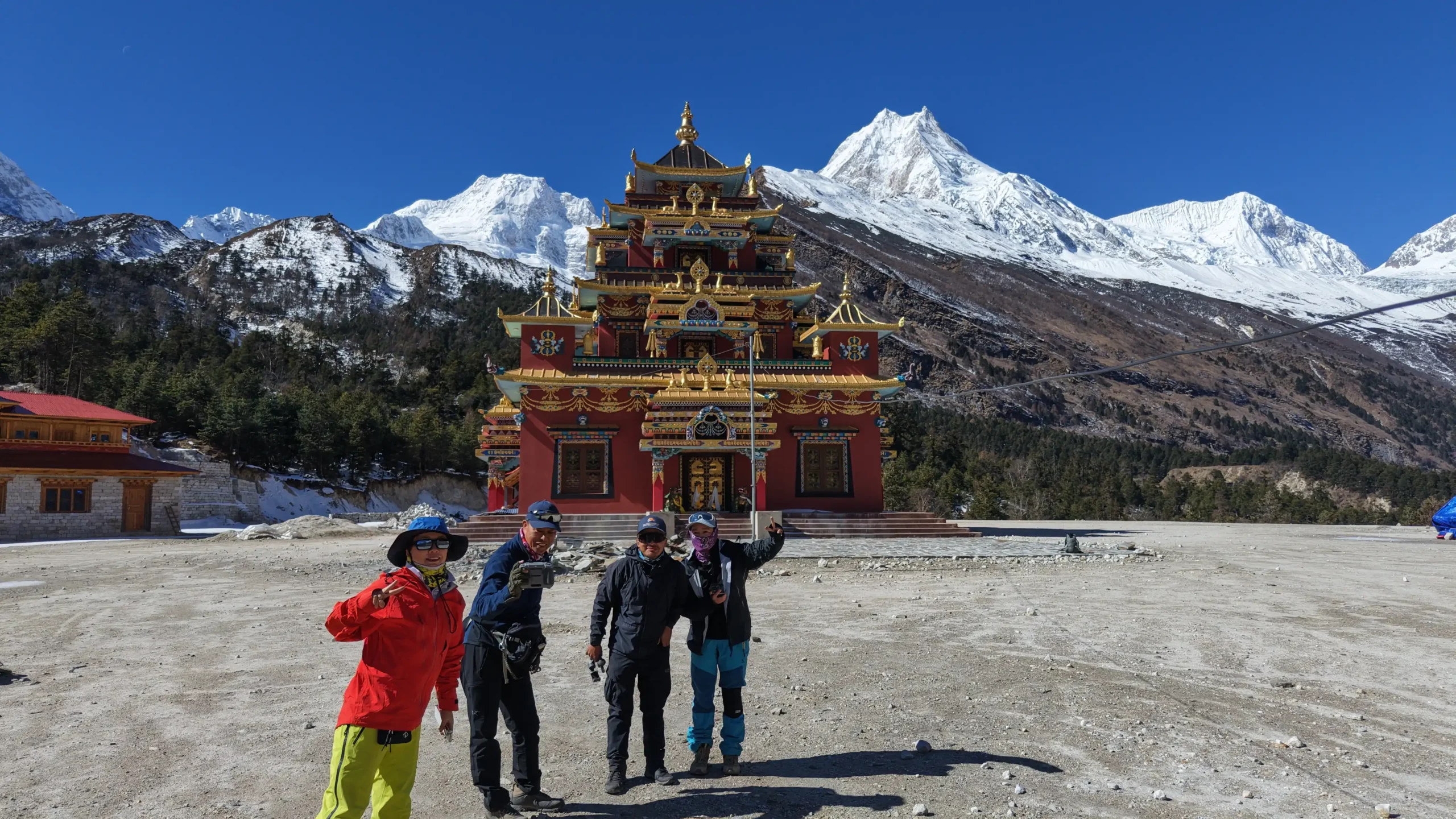
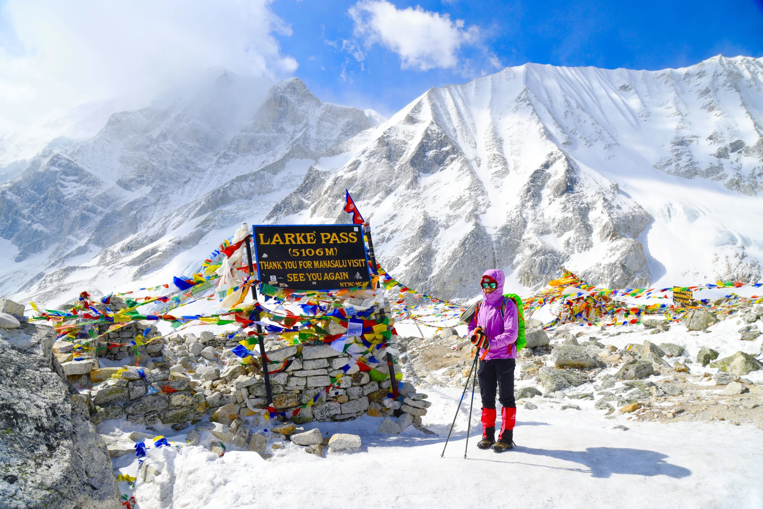
 Moderate